Rapa Nui National Park
Oceania / Pacific (Chilean territory, Easter Island), Chile · Cultural site · UNESCO World Heritage property #715

Ahu Tongariki, a restored platform of standing moai, photographed in March 2006. Shows the site as it was on that date, not its current condition.
Taken 2006-03-29 · Rivi · CC BY-SA 3.0 · Source

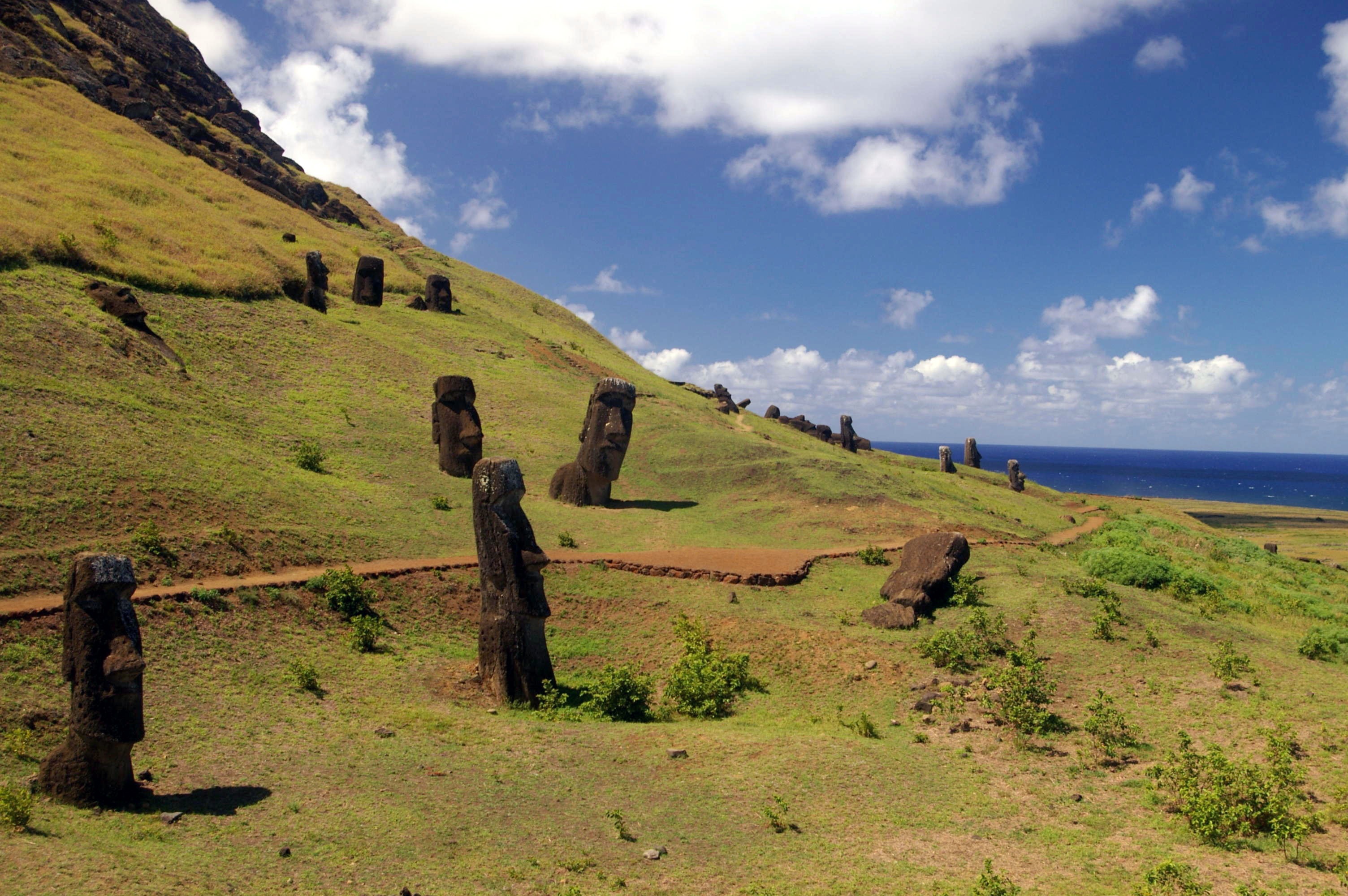
The Rano Raraku quarry, where the moai were carved, photographed in March 2006, before the October 2022 fire in this area. Not a record of its current condition.
Taken 2006-03-29 · Rivi · CC BY-SA 3.0 · Source

Significance
UNESCO describes Rapa Nui National Park as preserving the legacy of a society of Polynesian origin that settled Easter Island around A.D. 300 and developed a powerful, imaginative and original tradition of monumental art and architecture. Between the 10th and 16th centuries its people built approximately 900 moai statues and over 300 ceremonial platforms (ahu), which blend with the natural surroundings to form what UNESCO's brief synthesis calls an unparalleled cultural landscape. The park covers about 6,666 hectares, around 40% of the island, and was inscribed in 1995 under criteria (i), (iii) and (v).
Current Status Rationale
Historical damage is documented in the site's record, but the current classification is based on present conditions and the most recent credible evidence. Present conditions: Rapa Nui National Park is a well-documented, actively managed property with an engaged indigenous administration (Ma'u Henua, concession announced November 2017), international support (UNESCO Emergency Heritage Fund, USD 97,000), and active scientific work (a University of Barcelona team assessing fire damage with georadar and ultrasound in February 2025; CyArk and Binghamton University 3D documentation). It is not on the Danger List and no armed-conflict or access-collapse evidence exists. Against that, the October 2022 Rano Raraku fire is within the five-year window, UNESCO's 2023 diagnosis (as reported by La Tercera, which gives a fair-to-poor rating) recommended short-term treatment of 22 moai, and the most recent evidence found shows repair only beginning (reportedly five moai) with funding and approval constraints described by park officials. Chronic pressures also continue: erosion of soft tuff from water and climate (UNESCO's diagnosis names it the most harmful factor), and a 2025 modelling study projecting wave inundation of Ahu Tongariki by 2080 (a projection, not a current loss). Visitor and governance questions (a 30-day tourist stay limit since 2018, a 2020-2022 closure, financial disputes reported in 2019-2020 that were not verified as current) are context and do not by themselves drive the status. Confidence is Supported rather than Confirmed: the fire and the diagnosis are corroborated by UNESCO and independent reporting, but the deciding fact, how far repair has progressed, was last evidenced in mid-2025 from a single derivative source, several figures conflict across UNESCO pages and press (fire area, number of moai affected), and the Moderate/High boundary is a judgment call. Confidence does not alter the status.
Serious, currently active threats are documented, or major historical damage remains substantially unrepaired. Credible sources support this status, with some limits on corroboration.
Threat Categories
Material decay of the soft volcanic tuff is the most persistent condition problem. UNESCO's 2023 diagnosis (completed June 2023, published July 2023) evaluated 358 archaeological elements and found that erosion from climate and water was the most recurrent and most harmful factor, alongside biological growth (lichens, vegetation), fire and human activity. Reporting on that diagnosis (La Tercera, August 2023) says the overall condition was rated 'regular-malo' (fair to poor), and that UNESCO recommended prioritising 22 moai for short-term intervention (biodeterioration control, consolidation, hydrophobic treatment). UNESCO's property page also lists weathering of tuff, invasive vegetation, illegal cattle grazing and visitor management as management concerns; the underlying state-of-conservation text on that page may be dated (the report it links is from 1998). Visitor management and governance are part of the picture: the park has been administered by the Ma'u Henua indigenous community under a concession announced by Chile's Interior Ministry on 23 November 2017; the community has since sought outside funding for restoration (park director Nancy Rivera, quoted September 2023, said the community needed national, international and its own resources, and that restoration needed National Monuments Council approval before fundraising), and Mongabay reported audit findings and internal disputes in the early years of that administration (an audit period of October 2016 to June 2018, reported in 2019-2020; not verified as current). Tourist stays were limited to 30 days and residency tightened by a Chilean law in effect from 1 August 2018, with the mayor citing environmental strain; the island was closed to tourists for about 28 months during the pandemic (to August 2022). In 2025 the Ma'u Henua president described the community's model as combining protection with self-determination. Not found in this pass: current visitor-number figures or a formal carrying-capacity study for the park.
First identified: Not established — Documented as a chronic, long-running condition issue; no single start date identifiable from the sources reviewed.
Sources: UNESCO World Heritage Centre, UNESCO World Heritage Centre (news item 2587), La Tercera (Chile), El Desconcierto (Chile), Ministerio del Interior y Seguridad Publica (Chile), Panorama Solutions, Mongabay, The Jakarta Post (republishing AFP), Buenos Aires Times (republishing AFP), El Desconcierto (Chile)
On 4 October 2022 a fire swept through the Rano Raraku quarry and crater area of the park. UNESCO's sources give differing area figures (more than 100 hectares on its Emergency Heritage Fund page; approximately 240 hectares on its October 2022 mission page); NPR's report of about 250 acres (roughly 100 hectares) is consistent with the lower figure, so the 240 hectare figure is uncorroborated here and early moai-damage figures (177 moai reported as damaged in initial reports). UNESCO's later diagnosis found 22 moai with serious alterations among 358 archaeological elements evaluated. La Tercera's account of the diagnosis reports that fire damage was superficial (surface colour change and soot, with no observed fissures, cracks, fractures or displacements) and rated medium, with climate, moisture and biological factors a greater ongoing risk; El Desconcierto (September 2023) quotes archaeologist Daniela Meza that soot and heat damage weaken the tuff and accelerate erosion. NPR reported the mayor saying that all fires on Rapa Nui are caused by human beings; the official cause of this fire was not verified in this pass, so it is classed here under fire hazard (natural_disaster) as the closest of the four categories, not as a statement of cause. UNESCO funded a fire-risk management plan and training. A further hazard is storm and heavy-rain related erosion: UNESCO's diagnosis names water erosion as the most harmful agent, and CyArk's 2017 fieldwork notes that several ahu face erosion, especially following severe weather events. No documented storm-surge or tsunami damage to ahu in the last five years was found in this pass.
First identified: October 4, 2022
Sources: UNESCO World Heritage Centre (news item 2587), UNESCO, UNESCO, NPR (via Jefferson Public Radio), La Tercera (Chile), El Desconcierto (Chile), CyArk
A University of Hawai'i at Manoa study (lead author Noah Paoa, Journal of Cultural Heritage, reported in August 2025) used a digital model of the Tongariki area on the east coast and projected that seasonal waves could reach Ahu Tongariki by 2080 under sea-level-rise scenarios, with 51 cultural assets in the study area identified as threatened by coastal flooding (the figure applies to the study area, not the whole park). This is a modelled, long-range projection from a single academic study, not a documented current loss. CyArk has documented ahu at Rapa Nui since 2017 partly because of coastal erosion concerns. Infobae (July 2025) reports, without a primary source, that more than 90% of erected moai are near the coast; this is treated as indicative only.
First identified: Not established — Long-term, gradual trend; the 2025 study is the earliest dated source in this dossier and no single start date applies.
Sources: University of Hawai'i at Manoa (news release), CyArk, CyArk, Infobae
Historical Timeline
- 1995Rapa Nui National Park inscribed on the World Heritage List
At its 19th session the World Heritage Committee inscribed the park under criteria (i), (iii) and (v) (decision 19 COM VIII.C.1), describing it as containing one of the most remarkable cultural phenomena in the world.
Sources: UNESCO World Heritage Centre, UNESCO World Heritage Centre
- 1998State of conservation reported to the Committee (22 COM VII.43)
UNESCO's record of the 1998 report notes a Management Plan adopted in February 1998 and issues including a proposed harbour construction within the property (reported as abandoned by Chilean authorities) and stone extraction (said to be strictly controlled by the Council of National Monuments). The Committee asked Chile to keep it informed of future planning, infrastructure work and excavations.
Sources: UNESCO World Heritage Centre (state of conservation 2249)
- 2017-11-23Chile announces transfer of park administration to the Ma'u Henua community
Chile's Interior Ministry reported that President Bachelet handed administration of the park to the Ma'u Henua indigenous community under a 50-year renewable concession, described as covering sacred sites, moai and major tourist areas. A 2025 case study on Panorama Solutions describes the same governance model (self-reported).
Sources: Ministerio del Interior y Seguridad Publica (Chile), Panorama Solutions
- 2018-08-01Chilean law limits tourist stays and tightens residency on Easter Island
AFP reported that new rules in effect from 1 August 2018 cut tourist stays from 90 to 30 days and tightened residency requirements, citing population growth to 7,750 residents by 2017, waste and cultural pressures. AFP described new residents as needing to be related to Rapa Nui people or hold certain work roles; the law's text was not opened.
Sources: The Jakarta Post (republishing AFP)
- 2022-08-04Tourism resumes after about 28 months of closure
AFP reported that the first commercial flight carrying tourists landed in Hanga Roa after about 28 months of pandemic closure, with only two flights a week at first and most large hotels still closed.
- 2022-10-04Fire damages the Rano Raraku quarry and moai
A fire spread across the Rano Raraku crater and quarry area of the park. UNESCO pages give differing area figures (more than 100 hectares; approximately 240 hectares); NPR reported about 250 acres (roughly 100 hectares). NPR reported the park was closed to visitors and quoted the mayor saying all fires on Rapa Nui are caused by human beings. The cause of this fire was not verified here.
Sources: UNESCO, UNESCO, NPR (via Jefferson Public Radio)
- 2023-07-13UNESCO publishes diagnosis of fire damage
UNESCO reported that its assessment, completed in June 2023, evaluated 358 archaeological elements and found 22 moai with serious alterations requiring short-term intervention, with erosion from climate and water the most recurrent and harmful factor. La Tercera's account says 222 moai were included in the survey, that fire damage was superficial with no observed fractures, and that overall condition was rated fair to poor.
Sources: UNESCO World Heritage Centre (news item 2587), La Tercera (Chile)
- 2025-02University of Barcelona-led team begins scientific assessment of fire damage
A research team from the University of Barcelona with the Universities of Vigo and Copenhagen and the Ma'u Henua conservation team carried out fieldwork using georadar and ultrasound to examine the interior of fire-affected moai. The university said results were expected by the end of 2025; none were found.
Sources: Universitat de Barcelona
- 2025-08-12Study projects waves reaching Ahu Tongariki by 2080
The University of Hawai'i at Manoa reported a study in the Journal of Cultural Heritage that, using a digital model and sea-level-rise scenarios, projects seasonal waves could reach Ahu Tongariki by 2080, with 51 cultural assets in the study area threatened by coastal flooding.
- 2025-11-26Online 3D model of the Rano Raraku quarry published
Binghamton University researchers published a PLOS One paper alongside a photogrammetric 3D model of the Rano Raraku quarry (nearly 1,000 moai) that the release says is publicly viewable online.
Digital Preservation Index
Overall coverage: Extensive — Well documented across most or all digital preservation categories.
Four of five categories have publicly findable evidence, which meets the extensive tier by the rubric (at least four of five, including a visual category (virtual tour) and technical/scholarly ones). Coverage is uneven. Photographic is marked false conservatively: UNESCO's public gallery for the property appears to hold only a small set of images (19 images, credited to two photographers), and no larger institutional or archival image collection was found in this pass; this does not change the tier. The strongest evidence is 3D: CyArk's laser-scan and photogrammetry work (2007-2008 laser scanning, and December 2017 laser scanning and drone photogrammetry covering selected ahu, Ana Kai Tangata and Rano Raraku) and a 2025 Binghamton University photogrammetric model of the Rano Raraku quarry, which is viewable online. The virtual tour on CyArk's page was not walked through, so its scope is unverified. No whole-park 3D model was found; the model covers the quarry, a small fraction of the park's archaeological sites. Archival evidence rests on UNESCO's document index and the inscription record; the 1995 ICOMOS evaluation and 2023 periodic report were listed but not opened. A reviewer may wish to consider whether this uneven, site-selective coverage should temper the tier.
- Archival Records
UNESCO's documents page for the property lists a 1995 ICOMOS advisory body evaluation, the 1995 inscription decision (19 COM VIII.C.1), a 1998 state-of-conservation report, a 2013 retrospective Statement of Outstanding Universal Value decision and a 2023 Periodic Reporting Cycle 3 entry. The inscription decision and the 1998 summary were opened; the other listed documents were not.
View source - Three D Documentation
CyArk's page (dated 2009) describes 2007-2008 laser scanning and imaging of Easter Island moai, ahu and the Rano Raraku quarry, says CyArk is the internet host for much of that data, and links to the Rapa Nui project in its archive. The archive itself was not opened.
View source - Three D Documentation
CyArk's account of December 2017 fieldwork, working with local managers and Chile's National Monuments Commission, combining 3D laser scanning with terrestrial and drone photogrammetry at ahu, the Rano Raraku quarry and Ana Kai Tangata.
View source - Three D Documentation
Binghamton University researchers (Carl Lipo and colleagues) built a high-resolution photogrammetric 3D model of the Rano Raraku quarry (nearly 1,000 moai) described in a November 2025 PLOS One paper; the release says it is viewable online in an ArcGIS 3D viewer. The viewer link was not opened in this pass.
View source - Virtual Tour
CyArk's Rapa Nui project page offers a 3D virtual tour, explorable 3D models, video and lesson plans. Scope and capture dates are not stated on the page.
View source - Academic Scholarly
Peer-reviewed scholarship on the site's documentation and threats, as reported by university releases: a 2025 Journal of Cultural Heritage study of sea-level rise and wave inundation at Tongariki (University of Hawai'i at Manoa) and a November 2025 PLOS One paper on moai production based on the quarry model (Binghamton University). The papers themselves were not opened.
View source - Academic Scholarly
University of Barcelona-led research team (with University of Vigo and University of Copenhagen) conducting a scientific assessment of fire damage to moai, with georadar and ultrasound, from February 2025; results not found.
View source - Photographic
UNESCO World Heritage Centre hosts a public photo gallery (roughly 19 images) of moai, landscapes and archaeological features. Judged too small to count as a substantial body of professional or archival imagery for this rubric.
View source
Law and commitments
- Treaty record for Chile
Sources
- Rapa Nui National Park — UNESCO World Heritage Centre
- Decision 19 COM VIII.C.1: Inscription of Rapa Nui National Park (Chile) — UNESCO World Heritage Centre
- List of World Heritage in Danger — UNESCO World Heritage Centre
- UNESCO completes diagnosis of the state of conservation of Rapa Nui heritage resources after the 2022 fires — UNESCO World Heritage Centre (news item 2587) (flagged: context only)
- Emergency Heritage Fund (HEF) in Rapa Nui National Park (Chile) — UNESCO (flagged: context only)
- UNESCO visited Rapa Nui to support mitigation measures after fire at World Heritage site — UNESCO (flagged: context only)
- Rapa Nui National Park: photo gallery — UNESCO World Heritage Centre
- Rapa Nui National Park: documents — UNESCO World Heritage Centre (flagged: context only)
- The iconic Easter Island statues have been damaged in a fire, authorities say — NPR (via Jefferson Public Radio) (flagged: context only)
- Tras incendio de 2022: Unesco senala que moais en Rapa Nui presentan un estado de conservacion 'regular-malo' y recomienda tratar 22 piezas en el corto plazo — La Tercera (Chile) (flagged: context only)
- Tras un ano del feroz incendio, los moais de Isla de Pascua claman ser restaurados — El Desconcierto (Chile) (flagged: context only)
- Presidenta Bachelet entrega administracion del Parque Nacional Rapa Nui a la comunidad de Isla de Pascua — Ministerio del Interior y Seguridad Publica (Chile)
- Recovering the administration of ancestral land: establishment of the Indigenous Community Ma'u Henua — Panorama Solutions (flagged: context only)
- Fiscal meltdown of Easter Island park's management drives rift among islanders — Mongabay (flagged: context only)
- Chile to restrict tourists and non-locals on Easter Island (AFP) — The Jakarta Post (republishing AFP)
- Tourists return, but Easter Islanders draw lessons from Covid isolation (AFP) — Buenos Aires Times (republishing AFP)
- Rapa Nui's iconic moai statues threatened by sea level rise — University of Hawai'i at Manoa (news release) (flagged: context only)
- First-of-its-kind 3D model lets you explore Easter Island statues up close — Newswise (Binghamton University news release) (flagged: context only)
- Documenting the Archaeology of Rapa Nui — CyArk (flagged: context only)
- Monolithic Moai of Easter Island Captured in 3D — CyArk (flagged: context only)
- Rapa Nui project overview (3D virtual tour, 3D models, video, lesson plans) — CyArk (flagged: context only)
- UB researchers travel to Easter Island to study the conservation state of the Moai statues after the fire of 2022 — Universitat de Barcelona (flagged: context only)
- Los moais de Rapa Nui, en peligro por el cambio climatico y la erosion — Infobae (flagged: context only)
- Isla de Pascua cumple 30 anos como Patrimonio Mundial de la UNESCO — El Desconcierto (Chile)
- Rapa Nui National Park: state of conservation, 1998 (22 COM VII.43) — UNESCO World Heritage Centre (state of conservation 2249)